
Surveying is an ancient practice, but its importance in modern-day construction, land development, and mapping is undeniable. Whether you’re marking property boundaries, preparing for construction, or mapping out large areas of land, accurate measurements are crucial. The precision and reliability of these measurements depend heavily on the right tools. In this guide, we’ll explore the essential surveying equipment that professionals rely on to ensure accurate land measurements and successful projects.
The Importance of Accurate Land Measurements
Accurate land measurements are the foundation of any successful project. In construction, they ensure that structures are built on the right plots and within legal boundaries. In mapping, they provide the correct coordinates for everything from roads to public infrastructure. Without proper measurements, projects can suffer from delays, legal disputes, and costly mistakes.
Surveying equipment plays a critical role in gathering precise data. From establishing reference points to mapping large areas, these tools help surveyors provide accurate measurements that form the basis for engineering, construction, and land development.
Basic Surveying Equipment for Accurate Measurements
There is a wide range of surveying equipment available, each serving a specific purpose in the measurement process. Some tools are designed for measuring distance, while others are used for angles, elevations, and positioning. Here are some of the most essential tools used in modern surveying.
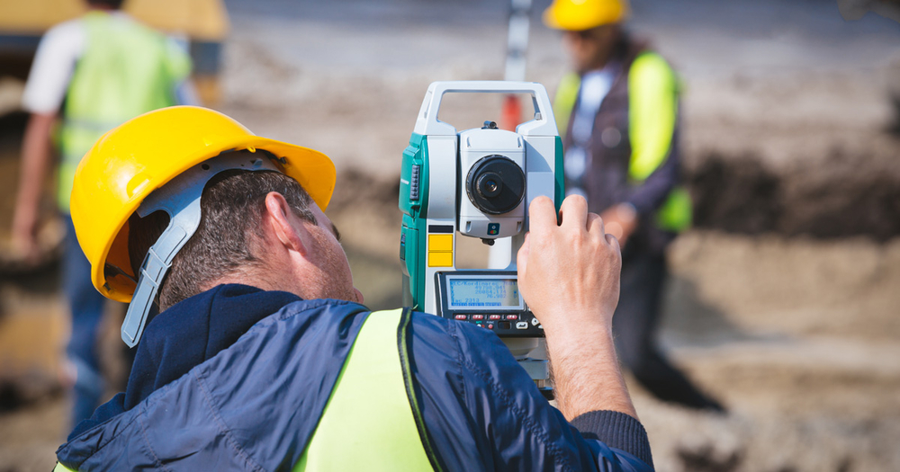
Theodolites and Total Stations
Theodolites have long been a staple of the surveying industry. This instrument measures horizontal and vertical angles, making it ideal for tasks that require precise angular measurements. Theodolites are often used in combination with other tools to establish accurate points across a landscape.
Total stations are an advanced version of theodolites, combining angle measurement with distance measurement. This all-in-one tool uses laser technology to calculate the exact distance between the instrument and a target, making it a popular choice for surveyors who need to gather data quickly and accurately. Total stations can also be integrated with GPS systems for even more precise positioning.
GPS Surveying Systems
Global Positioning System (GPS) technology has revolutionized the field of surveying. GPS surveying systems use satellite signals to determine exact coordinates on the earth’s surface. This technology is especially useful for large-scale projects where high accuracy is required over a wide area.
GPS surveying equipment allows surveyors to pinpoint locations with incredible precision, often within a few centimeters. The use of GPS reduces the time spent on site and increases the accuracy of measurements, making it an invaluable tool for land surveying.
Levels and Auto Levels
Levels are used to determine the elevation of points relative to a reference level. Traditional levels, such as the spirit level, have been used for centuries, but modern surveying often employs auto levels. Auto levels are more precise, using optics to create a horizontal line of sight, which ensures accurate elevation readings.
These tools are commonly used for tasks like grading, where determining the slope of land is critical. They allow surveyors to establish whether a surface is level and make necessary adjustments for construction or landscaping projects.
Advanced Surveying Tools for Enhanced Precision
While traditional tools like theodolites and levels remain essential, advances in technology have introduced new equipment that provides even greater precision and efficiency. Let’s look at some advanced tools that surveyors use for more complex projects.
Robotic Total Stations
Robotic total stations are the next step in the evolution of total stations. These instruments are controlled remotely, allowing surveyors to operate them from a distance without needing to be physically present at the site. This is particularly useful when working in challenging terrain or when a single surveyor needs to manage multiple tasks.
Robotic total stations offer increased speed and efficiency, as they can automatically track a target and provide real-time data. They also integrate seamlessly with other surveying equipment, such as GPS systems, to offer unparalleled accuracy in land measurements.
Drones for Aerial Surveying
Drones, or unmanned aerial vehicles (UAVs), are becoming increasingly popular in the field of surveying. Equipped with cameras, GPS, and advanced sensors, drones can capture aerial imagery and data that would otherwise be difficult or impossible to obtain from the ground. This makes them especially useful for surveying large or hard-to-reach areas.
By flying over a site, drones can create detailed 3D maps, provide topographical data, and capture high-resolution images for analysis. The use of drones significantly speeds up the surveying process and provides data that is often more detailed than what can be gathered from ground-level instruments.
Laser Scanners
Laser scanning is one of the most advanced techniques in modern surveying. Laser scanners use a laser beam to capture precise measurements of the distance between the scanner and surrounding objects. This technology is capable of creating highly detailed 3D models of landscapes, buildings, and other structures, making it ideal for projects that require extreme precision.
Laser scanners are often used in conjunction with traditional surveying equipment to enhance the accuracy of measurements. They are particularly valuable in projects where complex structures or terrain need to be mapped in detail.
The Role of Surveying Equipment in Project Success
In the middle of your surveying process, choosing the right equipment is crucial. The tools you select directly impact the accuracy of your measurements and the overall success of the project. Whether you’re working on a small plot of land or a large-scale construction site, reliable surveying equipment ensures that your measurements are precise, your work is efficient, and your project stays on track.
The best surveyors are those who understand the strengths and limitations of their equipment. They know when to use traditional tools like levels and theodolites and when to rely on advanced technologies such as GPS systems and laser scanners. By using the right equipment for each job, surveyors can ensure that their measurements are both accurate and efficient.
Keeping Your Surveying Equipment in Top Condition
Like any tools, surveying equipment requires regular maintenance to ensure it continues to function properly. Calibration is key to maintaining accuracy, as even the most advanced instruments can drift over time. Regularly cleaning and storing equipment in a controlled environment can also prolong its life and prevent damage.
Investing in high-quality surveying equipment is essential, but so is taking the time to care for it. Proper maintenance ensures that your tools provide reliable measurements for years to come, saving time and preventing costly errors on-site.
Conclusion
Surveying is a profession that demands precision, and the right equipment plays a critical role in achieving accurate land measurements. From basic tools like levels and theodolites to advanced technologies like GPS systems, robotic total stations, and drones, modern surveyors have a wide range of equipment at their disposal.
Using the appropriate surveying equipment not only ensures the success of your project but also streamlines the measurement process, saving time and reducing the likelihood of errors. By understanding the tools available and how to maintain them, you can confidently tackle any surveying task, knowing your measurements are accurate and your project is on the right track.