
Lake effect snow is a localized and intense snowfall event that occurs when cold air moves over relatively warmer lake waters, picking up moisture and heat. This interaction results in narrow but heavy bands of snow that can lead to rapid snow accumulation, reduced visibility, and hazardous travel conditions. A Lake Effect Snow Warning is issued by weather agencies to alert communities about impending severe snow events, urging them to take necessary precautions.
In this article, we will explore the mechanics of lake effect snow, how and why warnings are issued, the geographical regions most affected, preparation tips, and the impact on daily life. With a thorough understanding of this phenomenon, individuals and communities can better prepare for and respond to lake effect snow events.
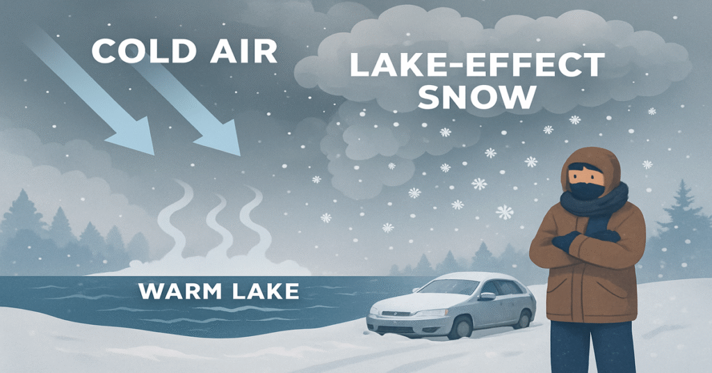
What is Lake Effect Snow?
How Lake Effect Snow Forms
Lake effect snow forms when a cold air mass moves over a warmer lake surface. The lake water warms the lower layer of the air, causing it to rise. As this air rises and cools, it condenses into clouds and precipitation—often intense snowfall. This process is most common during late fall and early winter when lake waters have not yet frozen, and cold arctic air masses sweep down from Canada.
Conditions for Development
Key conditions for lake effect snow formation include:
- A significant temperature difference between the lake surface and the air above (usually at least 13°C or 23°F).
- A long fetch, or the distance over which the wind travels across the lake, allowing the air to absorb maximum moisture.
- A directional wind flow that is consistent and perpendicular to the lake.
- Unstable atmospheric conditions, which promote upward air movement.
Geographic Areas Prone to Lake Effect Snow
The Great Lakes Region
The Great Lakes—Superior, Michigan, Huron, Erie, and Ontario—are the most common sites for lake effect snow in the United States. States like New York, Michigan, Ohio, Pennsylvania, and Indiana frequently receive heavy snowfalls due to lake effect events.
Other Areas
Lake effect snow can also occur near smaller lakes or even man-made reservoirs, though the intensity is generally less compared to the Great Lakes. In Canada, areas near Lake Ontario and Lake Erie are notably impacted.
What Triggers a Lake Effect Snow Warning?
Criteria for Issuing a Warning
A Lake Effect Snow Warning is typically issued when the following conditions are expected:
- Heavy snowfall rates of 2 inches or more per hour.
- Snow accumulations of 6 inches or more in 12 hours.
- Visibility reduced to less than a quarter-mile due to snow and blowing snow.
- High impacts to transportation and public safety.
These warnings are issued by the National Weather Service (NWS) in the United States or Environment Canada in Canada, depending on the region.
Difference Between Watch and Warning
- Lake Effect Snow Watch: Indicates that conditions are favorable for lake effect snow but not yet certain.
- Lake Effect Snow Warning: Implies that a significant event is imminent or already occurring.
Impacts of Lake Effect Snow Events
Transportation
Roads can become hazardous very quickly due to heavy snow accumulation and poor visibility. Accidents and road closures are common during intense lake effect snow.
Infrastructure
Snow buildup can lead to:
- Power outages due to heavy snow on power lines.
- Roof collapses from weight.
- Strain on snow removal resources and emergency services.
Daily Life
- School and business closures are frequent.
- Emergency preparedness becomes crucial.
- Outdoor activities may be restricted.
Preparation and Safety Tips
Before the Storm
- Monitor forecasts: Stay updated with local weather alerts.
- Winterize your home: Insulate pipes, check heating systems, and stock up on essentials.
- Prepare an emergency kit: Include food, water, flashlights, batteries, and medication.
During the Storm
- Stay indoors: Limit travel unless necessary.
- Drive cautiously: If you must travel, reduce speed and increase following distance.
- Clear snow regularly: Prevent snow from building up around doorways and ventilation.
After the Storm
- Check on neighbors: Especially the elderly and those with limited mobility.
- Clear driveways and sidewalks: Use salt or sand to reduce slipping.
- Stay informed: Continue monitoring updates as bands may shift.
Emergency Response and Community Coordination
Role of Local Authorities
- Issue warnings and emergency alerts.
- Deploy snow plows and salting teams.
- Open shelters for those in need.
Community Involvement
- Join local preparedness groups.
- Share resources with neighbors.
- Volunteer for snow-clearing services or emergency support.
Technology and Tools for Forecasting
Weather Models
Advanced forecasting models like the HRRR (High-Resolution Rapid Refresh) and GFS (Global Forecast System) are used to predict lake effect snow behavior.
Radar and Satellite
Weather radar and satellite imagery help meteorologists track snow bands and determine their intensity, direction, and potential impact areas.
Mobile Alerts
Smartphones and apps now deliver real-time lake effect snow warnings, helping individuals stay informed and take quick action.
Climate Change and Lake Effect Snow
Shifting Patterns
Climate change is causing warmer lake temperatures and less ice cover, which may lead to:
- More intense lake effect snow events.
- Longer snow seasons.
- Increased unpredictability in snowfall distribution.
Research and Projections
Scientists continue to study the impact of a warming climate on lake effect snow to improve preparedness and forecasting accuracy.
Conclusion
Lake effect snow is a complex weather phenomenon that can have serious consequences for transportation, infrastructure, and everyday life. Understanding the science behind it, recognizing warning signs, and taking proactive measures can greatly enhance safety and resilience. By staying informed and prepared, individuals and communities can mitigate the risks associated with lake effect snow events.
FAQs
1. What is the main cause of lake effect snow?
The main cause is cold air passing over warmer lake waters, which generates moisture-laden clouds and heavy snow.
2. How much snow typically falls during a lake effect event?
Snowfall can vary widely but may exceed 2 feet in localized areas under persistent snow bands.
3. How far inland does lake effect snow typically travel?
Snow bands can extend 30 to 100 miles inland, depending on wind patterns and terrain.
4. Can lake effect snow happen at night?
Yes, lake effect snow can occur at any time of day as long as the atmospheric conditions are favorable.
5. How do I know if I’m in a lake effect snow zone?
If you live near the Great Lakes or a large body of water known for such activity, check your local weather office for maps and alerts.
6. What is the best way to stay informed about lake effect snow warnings?
Use weather apps, listen to local radio or TV broadcasts, and sign up for emergency alert systems.